

The only settlement on the island is also called Kaprije
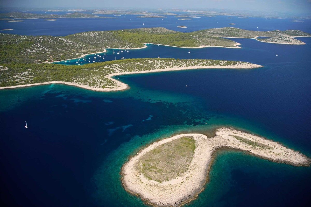
Kaprije is an island located in the central part of the Šibenik archipelago. It is located about 15 kilometers southwest of Šibenik, its surface area is 7.11 km2 and the total length of the coast is 25.211 km, with a development index of 2.56. The only settlement on the island is also called Kaprije, which is surrounded by hills, the highest of which is Velika glavica (129 m). It is named after the Mediterranean caper plant, the buds of which serve as a spice. It is separated from neighboring islands by sea passages and canals, as well as the waterway of the Murter Sea. To the northeast are Prvić, Tijat and Zmajan (Orut) with smaller islets, from which it is separated by the Kaprije channel, to the southwest is the island of Žirje with its associated islets, from which it is separated by the channel of Žirje, and from Kakan (in the west) is separated by the channel of Kakan, on which there are the islets Borovnjak Mali and Borovnjak Veliki.
Coves:
There are about 20 coves on the island of Kaprije, the most famous of which are:
Port of St. Peter (Luka Kaprije) is the main and largest cove on the island where the coastal part of the Kaprije settlement is located. There is a ferry dock with moorings. The deepest point is about 15 meters.
Mala Nozdra is a cove located southeast of the village of Kaprije. It is uninhabited, but there is a restaurant and moorings for yachts. There is a paved road from Kaprije to Nozdra.
Velika Nozdra
Gračice (Gačice)
Remetić
Climate
The area around Kaprije, but also the entire Šibenik archipelago, according to statistical indicators of the basic climate elements, is characterized by the Csa climate type (Mediterranean climate with dry hot summer or olive climate) according to Köppen, i.e. sub humid or semi-humid climate according to Thornthwaite's classification. The basic climate characteristics and prevailing weather types mostly fit into the climate-meteorological patterns of the Croatian Adriatic. There are no measuring stations on Kaprije, so conclusions about the climate of the island can be made on the basis of a comparative analysis of meteorological data from the main meteorological stations in Zadar and Šibenik, climatological stations in Biograd, Božava and Vela Sestra and rain gauge stations in Babac, Brbinje, Pirovac, Primošten, Rogoznica, Salima, Sukošan, Ugljan, Veli Iža, Vodice and Zlarin.
The average annual length of sunshine, or insolation, is about 2,600 hours, making this area one of the sunniest parts of the Mediterranean. On average, during the year, every third day is clear (cloud cover is less than 2/10). The average cloud cover of the Zadar-Sibenik coast ranges from 3.5 tenths of the sky (Božava) to 4.8 tenths of the sky (Šibenik). These facts alone, of course, in accordance with all other relevant climate indicators, point to the possibilities of tourism valorization during most of the year, especially for those tourists who are attracted to the Croatian coast because of the mild and pleasantly warm climate. The importance of high insolation is, of course, particularly great for the development of the Mediterranean plant cover, on which, among other things, the cultivation of olives and vines, the main island crops, depends. The annual course of the air temperature is transitional maritime-continental, because the annual amplitude of the air temperature is between 15 °C and 20 °C.
History
In the 14th century, the island was owned by the Ljubić family, and from 1500 it belonged to the Šibenik noble family Divić (Difnico). The first settlement on Kaprije began in the 15th century, and in the 16th century even more because of the invasion of the Turks, so people from the mainland sought refuge on the islands. The first study on these islands was written by priest P. Kaer, who wrote extensively about the Jelovčić and Radovčić families, who moved to Kaprije, then still owned by the Divnić (Difnico) family, at the beginning of the 16th century. At that time, Kaprije was important due to lime. So, for example, in 1560, 50 modi of lime (437,70 liters) were produced for the construction of the Sibenik infirmary on Kaprije. Most of it was mined in Medoš, near Cape Kaprije. In the village there is a church of St. Petra which was built at the turn of the 16th and 17th centuries. century, and expanded in 1801.
World War II
Kaprije during second World War was occupied by fascists. Their base was located on the neighboring island of Kakan in the bay of Tratica, where there are still buildings, bunkers, reconnaissance posts, etc. Many people from Kaprije then went to defend the country and many died in the process. Today, there is a monument to all fallen fighters in the central square. On March 22, 1944, the German warship Francesca da Rimini anchored near the northern tip of Kaprije. It was anchored at least fifty meters from the shore, the ship was anchored due to engine failure, and it was masked with straw, so it looked like an extension of the tip of the island. On that day, probably on the report of the Partizans from Žirje, it was sunk. Today, the ship lies at a depth of 55 meters next to the northern tip of the island and is an attractive location for diving.
Homeland war
Kaprije did not suffer any damage or destruction during the Homeland War, but its inhabitants helped the villagers of Žirje. They were carrying grenades on the island of Žirje, and later formed the Kaprije cannon unit and helped put out fires on September 18, 1991. which were caused by the shelling of the village of Žirje.
Transport and connection with the mainland
Kaprije is connected to the mainland, i.e. to Šibenik, by a ferry line and a subsidized high-speed ferry line that runs two to three times a day on average. The Jadrolinija ferry goes to the island, which, in addition to Kaprije, also goes to Žirje, and twice a week to Zlarin. Despite the ferry connection, cars are not allowed on the island due to the underdeveloped infrastructure. There are only small and narrow roads on the island. In the future, it is planned to build a parking lot and widen the existing roads.
Infrastructure
The island is not connected to the regional water supply system of the Šibenik-Knin County, that is, the North Dalmatian water supply system. Water is provided by collecting rainwater in our own water reservoirs (gusterna), or in dry periods by delivering it with water carrying ships. In the years when there were disruptions in water supply by water carriers, the population and guests were exposed to scarcity and forced savings measures. The island also has a public (local) water reservoir, and a new water reservoir with a volume capacity of 500 m³ of water, which is filled with water brought by water carriers and a local water supply network with about 250 connections was recently built.